Sweden Topo Maps
4.4امتیاز
Jul 26, 2024آخرین به روزرسانی
1.0.7نسخه
چگونگی نصب فایل XAPK / APK
اشتراک گذاری
درباره Sweden Topo Maps
Easy to use Outdoor/Offline GPS navigation app with access to the best topographic maps and satellite images for Sweden.
++ For offline use PRO features needed ! ++
Turn your Andoid Phone/Tablet into an outdoor GPS for trips into the backcountry WITHOUT CELL COVERAGE. This app gives you similar mapping options as you might know from Garmin or Magellan GPS handhelds.
Included FREE map layers:
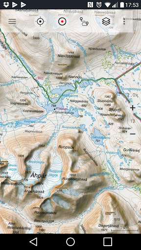
• Topographic Map 1:50.000 for Scandinavia ( Denmark, Norway, Sweden und Finland) with hillshading. Lantmateriet Terrängkartan + Fjällkartan
• Topowebb Lantmateriet Topographic Map for Sweden
• OpenStreetMaps : These crowdsourced maps are a very useful addition to other map layers. Contains many unique features.
• OpenCycleMaps: These maps are ideal to plan bicycle trips (PRO Users only !)
• ESRI Topographic
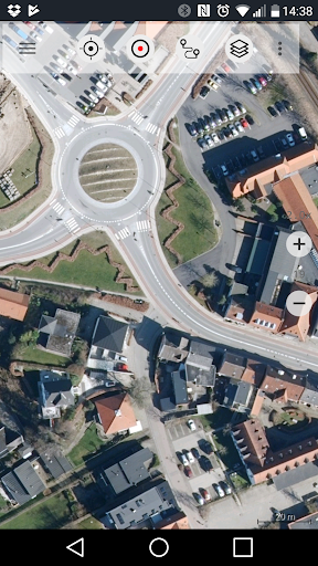
• ESRI Aerial Images
• ESRI Street Map
• Google Road Map (online access only)
• Google Satellite Images (online access only)
• Google Terrain Map (online access only)
• Bing Road Map (online access only)
• Bing Satellite Images (online access only)
• Earth At Night
• Hillshading overlay
Main features for outdoor-navigation:
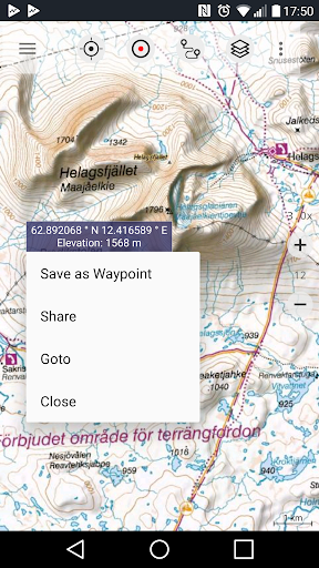
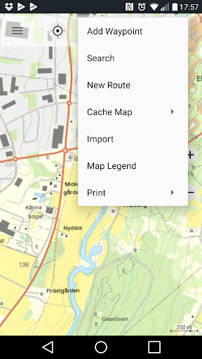
• Create and edit Waypoints
• GoTo-Waypoint-Navigation
• Track Recording (with speed, elevation and accuracy profile)
• Tripmaster with fields for odometer, average speed, bearing, elevation, etc.
• GPX/KML/KMZ Export
• Search (placenames, POIs, streets)
• Customizable datafields in Map View and Tripmaster (e.g. Speed, Distance, Compass, ...)
• Share Waypoints, Tracks or Routes (via eMail, Whatsapp, Dropbox, Facebook, ..)
• Display coordinates in Lat/Lon, UTM or MGRS/USNG (Military Grid/ US National Grid)
• Record & share tracks with statistics & elevation profile
• Rotate map (Track Up & North Up)
• Get Elevation and Distance by long click on map
• Track Replay
• Add custom map tile servers
• and many more ...
Available Pro features: (Pro features available via In App Purchase)
• Offline Use - no cell coverage needed. No Roaming fees !
• Easy+Fast Bulk-download of map tiles for OFFLINE USAGE (not for Google and Bing maps)
• Create and edit Routes
• Route-Navigation (Point-to-Point Navigation)
• GPX/KML/KMZ Import/Export
• unlimited Waypoints & Tracks
• Add other Map Tile-Server
• No Ads
Offline Use:
All viewed map tiles are kept in cache. To cache large areas you need to purchase Pro features.
Use this navigation app for outdoor activities like hiking, biking, camping, climbing, riding, skiing, canoeing, hunting, offroad 4WD tours or search&rescue (SAR).
Add custom waypoints in longitude/latitude, UTM or MGRS/USNG format with WGS84 datum.
Import/Export/Share GPS-Waypoints/Tracks/Routes in GPX or Google Earth KML/KMZ format.
Preload FREE map data for areas without cell service (Pro feature !).
Comments and feature requests to swedenmaps@atlogis.com
Have a look at our other outdoor navigation apps: https://play.google.com/store/search?q=atlogis
+++ We DO NOT track any user activities or collect any user data ! +++
++ For offline use PRO features needed ! ++
Turn your Andoid Phone/Tablet into an outdoor GPS for trips into the backcountry WITHOUT CELL COVERAGE. This app gives you similar mapping options as you might know from Garmin or Magellan GPS handhelds.
Included FREE map layers:
• Topographic Map 1:50.000 for Scandinavia ( Denmark, Norway, Sweden und Finland) with hillshading. Lantmateriet Terrängkartan + Fjällkartan
• Topowebb Lantmateriet Topographic Map for Sweden
• OpenStreetMaps : These crowdsourced maps are a very useful addition to other map layers. Contains many unique features.
• OpenCycleMaps: These maps are ideal to plan bicycle trips (PRO Users only !)
• ESRI Topographic
• ESRI Aerial Images
• ESRI Street Map
• Google Road Map (online access only)
• Google Satellite Images (online access only)
• Google Terrain Map (online access only)
• Bing Road Map (online access only)
• Bing Satellite Images (online access only)
• Earth At Night
• Hillshading overlay
Main features for outdoor-navigation:
• Create and edit Waypoints
• GoTo-Waypoint-Navigation
• Track Recording (with speed, elevation and accuracy profile)
• Tripmaster with fields for odometer, average speed, bearing, elevation, etc.
• GPX/KML/KMZ Export
• Search (placenames, POIs, streets)
• Customizable datafields in Map View and Tripmaster (e.g. Speed, Distance, Compass, ...)
• Share Waypoints, Tracks or Routes (via eMail, Whatsapp, Dropbox, Facebook, ..)
• Display coordinates in Lat/Lon, UTM or MGRS/USNG (Military Grid/ US National Grid)
• Record & share tracks with statistics & elevation profile
• Rotate map (Track Up & North Up)
• Get Elevation and Distance by long click on map
• Track Replay
• Add custom map tile servers
• and many more ...
Available Pro features: (Pro features available via In App Purchase)
• Offline Use - no cell coverage needed. No Roaming fees !
• Easy+Fast Bulk-download of map tiles for OFFLINE USAGE (not for Google and Bing maps)
• Create and edit Routes
• Route-Navigation (Point-to-Point Navigation)
• GPX/KML/KMZ Import/Export
• unlimited Waypoints & Tracks
• Add other Map Tile-Server
• No Ads
Offline Use:
All viewed map tiles are kept in cache. To cache large areas you need to purchase Pro features.
Use this navigation app for outdoor activities like hiking, biking, camping, climbing, riding, skiing, canoeing, hunting, offroad 4WD tours or search&rescue (SAR).
Add custom waypoints in longitude/latitude, UTM or MGRS/USNG format with WGS84 datum.
Import/Export/Share GPS-Waypoints/Tracks/Routes in GPX or Google Earth KML/KMZ format.
Preload FREE map data for areas without cell service (Pro feature !).
Comments and feature requests to swedenmaps@atlogis.com
Have a look at our other outdoor navigation apps: https://play.google.com/store/search?q=atlogis
+++ We DO NOT track any user activities or collect any user data ! +++
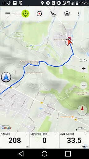
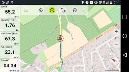
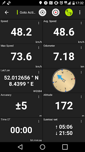
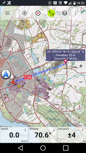
تصاویر Sweden Topo Maps
نسخههای قدیمی Sweden Topo Maps


Sweden Topo Maps FAQ
چگونه می توانم Sweden Topo Maps را از PGYER APK HUB دانلود کنم؟
آیا Sweden Topo Maps در PGYER APK HUB رایگان برای دانلود است؟
آیا برای دانلود Sweden Topo Maps از PGYER APK HUB نیاز به حساب کاربری دارم؟
چگونه می توانم یک مشکل با Sweden Topo Maps در PGYER APK HUB گزارش دهم؟
آیا این را مفید یافتید؟
بله
خیر
نظرات کاربران
+ نقد و بررسی
4.4
5
4
3
2
1
پرطرفدارترین
BERSHKA
Inditex
4.8Poppy Playtime Chapter 4
RICHIEMANMARIO ALT
-PRX XIT MOBILE PANEL
PRX XIT MOBILE PANEL - Comprehensive Overview
Introduction
Discover the PRX XIT MOBILE PANEL, a cutt
4.9Adobe Acrobat Reader: Edit PDF
Adobe
4.6ENUYGUN
WINGIE ENUYGUN GROUP
4.7Bluetooth LE Spam
Bluepixel Technologies
4.9KOPLO77
KOPLO77 APK - Comprehensive Overview
Discover the vibrant world of KOPLO77, an innovative applicatio
4.6JioCinema
JioCinema APK - Your Ultimate Streaming Experience
Description:
JioCinema is a cutting-edge video st
4.9ZEE5
Z5X Global FZ LLC
4.7PLN Mobile
P L N
4.7Vidio: Sports, Movies, Series
PT Vidio Dot Com
4.1MiChat - Chat, Make Friends
MICHAT PTE. LIMITED
4.0Getcontact
Getverify LDA
4.5SuperFishing Casino- Slots 777
Joyous.games
4.6ChatGPT
OpenAI
4.8TippoParty
TippoParty
4.6WePlay(ويبلاي) - Game & Chat
WEJOY Pte. Ltd.
4.6RAJANEKO
RAJANEKO: Your All-in-One Japanese Language Companion
Begin your immersive journey into the world of
4.9Grand Theft Auto: San Andreas
Rockstar Games
4.9Max: Stream HBO, TV, & Movies
WarnerMedia Global Digital Services, LLC
4.7App Market
Oppo
4.6Higgs Domino Global
Higgs Games
4.8Microsoft Word: Edit Documents
Microsoft Corporation
4.6Game Booster VIP Lag Fix & GFX
TOLAN
4.8