Polaris GPS Navigation
4.2Rating
Aug 02, 2024Latest update
9.25Version
About Polaris GPS Navigation
Easy-to-use high performance GPS for wherever your travels take you. No account setup or subscriptions required.
Turn your phone into a powerful GPS navigation system with Polaris Navigation GPS, the most accurate all-purpose GPS, and dare to go where there are no roads.
Imagine... What would it be like to navigate any waterway or hike any wilderness or city using only your phone's GPS location abilities and a view of the sky? What it would be like to create navigation destinations without the need of an internet connection and find them using offline maps or a waypoint pointing arrow.
That is just a glimpse of the navigational power you will hold in your hands when you install Polaris Navigation GPS.
Used mostly as a hiking, off road, nautical and trail GPS app, Polaris is an excellent backup or replacement for your dedicated GPS satellite navigation unit and will keep you oriented wherever your outdoor adventures take you!
Typical usage:
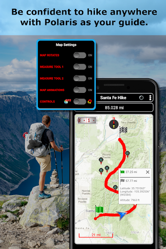
● Waypoint navigation.
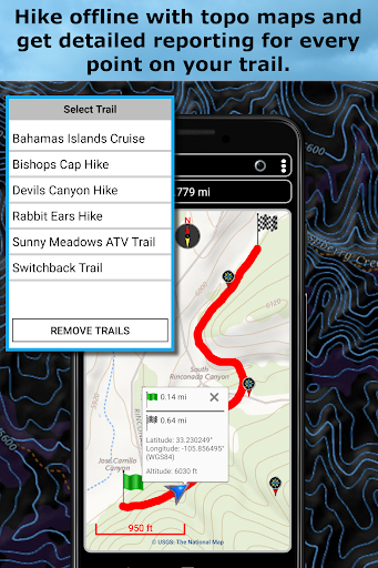
● Hiking GPS with the best hiking maps! Search and find nearby trails.
● Back country exploration and outdoor adventure.
● Record tracks and navigate trails.
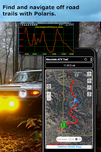
● Offroad navigation support for your ATV, Jeep or other 4x4 vehicle.
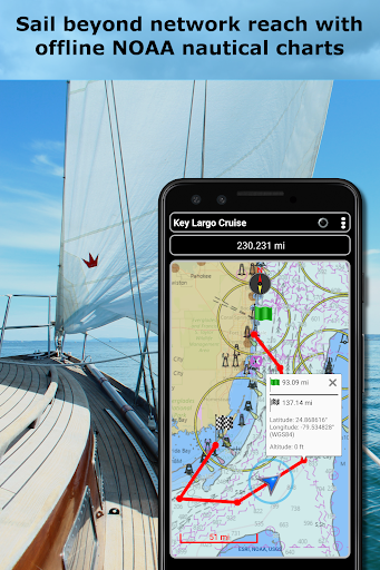
● Sailing / Boating. All marine navigation charts in Polaris are free.
● Fishing GPS. Easily find you favorite fishing hole.
● Hunting and hunting maps. Find you favorite hunting blind and your way back!
● Geocache
● Camping
● Mountain Biking and bike maps
● Backpacking and other outdoor sports
● Compass orienteering
Known for its stability, reliability and flexibility, Polaris is used by land-sea search and rescue, military personnel and millions of others worldwide.
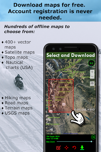
For your offline adventures we provide:
📡 Unlimited free access to our offline vector & raster maps (topographic maps, marine, hiking and others).
📡 Offline nautical charts for the USA included (ENC's and raster).
This powerful navigation system also includes:
📡 Polaris Places Picker. Find hiking trails, camping locations and much more!
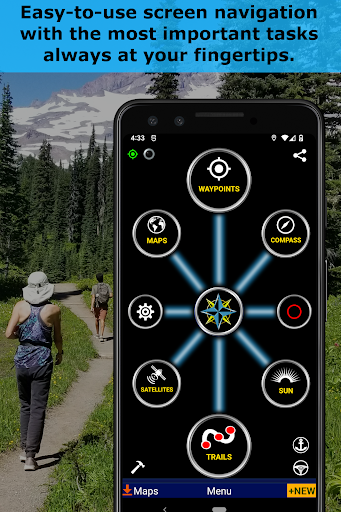
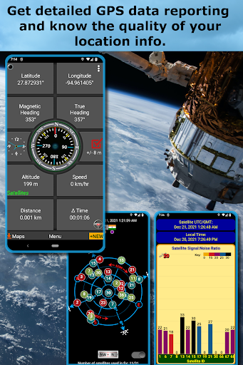
📡 GPS compass and magnetic compass.
📡 GPS info panel.
📡 Odometers, altimeters, speedometers, chronometers.
📡 Split distances on tracks.
📡 Connect your waypoints and navigate the track they define.
Map Types:
- Google Maps
- OpenStreetMap-Mapnik
- Topographic Maps
- Cycle Route and Hiking Maps
- Vector Maps
- USGS Topo
- NOAA Marine Charts
- Aviation Operations Charts
- Canada Toporama
📡 Comprehensive set of GPS Tools and diagnostics.
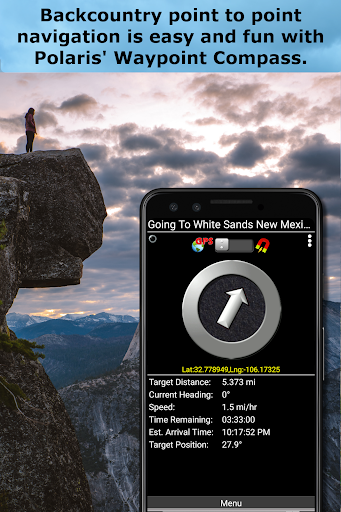
📡 Waypoint navigation system including a dynamic waypoint-finding compass that always points to your destination while reporting estimated time of arrival, distance to target and other statistics. Just follow the arrow!
📡 Trail navigation system
📡 Altitude profiles
📡 Location sharing
📡 Supports British OSGR and OSGB-36 DATUM (Ordnance Survey Grid).
📡 Coordinate formats: latitude/longitude as degrees, deg:min, deg:min:sec, and UTM (Universal Transverse Mercator)
📡 Military Coordinate Finder - Military Grid Coordinate Reference System (MGRS)
📡 Hiking Trails - Most of the maps show hiking paths courtesy of the Openstreetmap project. You will find that even some of the most remote hiking routes are visible on our maps.
⚓ Marine navigation- NOAA Nautical Charts and nautical unit reporting.
⚓ Drift alert / Drag anchor alarm.
📡 Select source for altitude reporting: Satellites, United States Geologic Survey or map your location to the results of NASA's Space Shuttle Radar Topography Mission.
📡 Waypoint photos stamped with coordinates.
📡 Road navigation and street directions are provided through a digital pipeline connecting the power of Polaris to the Google Maps app on your device.
* The premium version of Polaris Navigation is called GPS Waypoints Navigator, available on Google Play. GPS Waypoints Navigator is ad-free and contains many other enhancements.
Turn your phone into a powerful GPS navigation system with Polaris Navigation GPS, the most accurate all-purpose GPS, and dare to go where there are no roads.
Imagine... What would it be like to navigate any waterway or hike any wilderness or city using only your phone's GPS location abilities and a view of the sky? What it would be like to create navigation destinations without the need of an internet connection and find them using offline maps or a waypoint pointing arrow.
That is just a glimpse of the navigational power you will hold in your hands when you install Polaris Navigation GPS.
Used mostly as a hiking, off road, nautical and trail GPS app, Polaris is an excellent backup or replacement for your dedicated GPS satellite navigation unit and will keep you oriented wherever your outdoor adventures take you!
Typical usage:
● Waypoint navigation.
● Hiking GPS with the best hiking maps! Search and find nearby trails.
● Back country exploration and outdoor adventure.
● Record tracks and navigate trails.
● Offroad navigation support for your ATV, Jeep or other 4x4 vehicle.
● Sailing / Boating. All marine navigation charts in Polaris are free.
● Fishing GPS. Easily find you favorite fishing hole.
● Hunting and hunting maps. Find you favorite hunting blind and your way back!
● Geocache
● Camping
● Mountain Biking and bike maps
● Backpacking and other outdoor sports
● Compass orienteering
Known for its stability, reliability and flexibility, Polaris is used by land-sea search and rescue, military personnel and millions of others worldwide.
For your offline adventures we provide:
📡 Unlimited free access to our offline vector & raster maps (topographic maps, marine, hiking and others).
📡 Offline nautical charts for the USA included (ENC's and raster).
This powerful navigation system also includes:
📡 Polaris Places Picker. Find hiking trails, camping locations and much more!
📡 GPS compass and magnetic compass.
📡 GPS info panel.
📡 Odometers, altimeters, speedometers, chronometers.
📡 Split distances on tracks.
📡 Connect your waypoints and navigate the track they define.
Map Types:
- Google Maps
- OpenStreetMap-Mapnik
- Topographic Maps
- Cycle Route and Hiking Maps
- Vector Maps
- USGS Topo
- NOAA Marine Charts
- Aviation Operations Charts
- Canada Toporama
📡 Comprehensive set of GPS Tools and diagnostics.
📡 Waypoint navigation system including a dynamic waypoint-finding compass that always points to your destination while reporting estimated time of arrival, distance to target and other statistics. Just follow the arrow!
📡 Trail navigation system
📡 Altitude profiles
📡 Location sharing
📡 Supports British OSGR and OSGB-36 DATUM (Ordnance Survey Grid).
📡 Coordinate formats: latitude/longitude as degrees, deg:min, deg:min:sec, and UTM (Universal Transverse Mercator)
📡 Military Coordinate Finder - Military Grid Coordinate Reference System (MGRS)
📡 Hiking Trails - Most of the maps show hiking paths courtesy of the Openstreetmap project. You will find that even some of the most remote hiking routes are visible on our maps.
⚓ Marine navigation- NOAA Nautical Charts and nautical unit reporting.
⚓ Drift alert / Drag anchor alarm.
📡 Select source for altitude reporting: Satellites, United States Geologic Survey or map your location to the results of NASA's Space Shuttle Radar Topography Mission.
📡 Waypoint photos stamped with coordinates.
📡 Road navigation and street directions are provided through a digital pipeline connecting the power of Polaris to the Google Maps app on your device.
* The premium version of Polaris Navigation is called GPS Waypoints Navigator, available on Google Play. GPS Waypoints Navigator is ad-free and contains many other enhancements.
Gameplay
Polaris GPS Navigation Screenshots
Old Versions of Polaris GPS Navigation


Apps Like Polaris GPS Navigation
 Polaris GPS Navigation4.2
 Voice Navigation GPS: GPS Voice Live Mapquest4.7
 Voice GPS Driving: GPS Navigation Direction4.9
 GPS Maps Navigation GPS Camera4.6
 CoPilot GPS Navigation4.6
 Maps & GPS Navigation4.9
 Find My Car - GPS Navigation4.9
 GPS Offline Maps & Navigation4.6
 GPS Navigation And Tracker4.8
 Live MAPS & GPS Navigation4.6
 GPS Navigation4.7
 Petal Maps – GPS & Navigation4.2
Apps by Disciple Skies Software
- Find My Car - GPS Navigation4.9
 MAP GAME LITE4.9
 DS Speedometer & Odometer4.9
 Bible Trivia Wheel4.9
 DS Barometer & Altimeter4.8
 GPS Reset COM - GPS Repair4.6
 DS Speedometer Custom4.6
 Forbidden Math4.6
 GPS Waypoints Navigator | MAPS4.5
 Walking Odometer Pro4.4
 Altimeter & Altitude Widget4.3
 Satellite Check: GPS Tools4.2
Polaris GPS Navigation FAQ
How do I download Polaris GPS Navigation from PGYER APK HUB?
Is the Polaris GPS Navigation on PGYER APK HUB free to download?
Do I need an account to download Polaris GPS Navigation from PGYER APK HUB?
How can I report a problem with Polaris GPS Navigation on PGYER APK HUB?
Did you find this helpfull
Yes
No
User Reviews
+ Reviews
4.2
5
4
3
2
1
G
Gillian
2025-01-27
20
0
Polaris GPS Navigation is an exceptional app that provides accurate and reliable directions. It's my go-to navigation tool!
G
Gavin
2025-01-05
15
0
I've tried many GPS apps, but Polaris GPS Navigation stands out with its user-friendly interface and precise route tracking.
C
Christian
2025-01-15
27
0
Polaris GPS Navigation has made my daily commutes so much easier. The real-time updates are incredibly helpful.
Most Popular
Hyper
Hyper
4.9Microsoft Word: Edit Documents
Microsoft Corporation
4.6PRX XIT MOBILE PANEL
PRX XIT MOBILE PANEL - Comprehensive Overview
Introduction
Discover the PRX XIT MOBILE PANEL, a cutt
4.9Mega888
Mega888 APK - Ultimate Gaming Experience at Your Fingertips
Overview:
Discover the thrilling world o
4.6KOPLO77
KOPLO77 APK - Comprehensive Overview
Discover the vibrant world of KOPLO77, an innovative applicatio
4.6LostLife
Lost Life APK Download and Guide
Today, we're exploring Lost Life, a popular 3D simulation horror ga
4.9PLN Mobile
P L N
4.7Aviator Predictor
Сергей Братухин
-MiChat - Chat, Make Friends
MICHAT PTE. LIMITED
4.0WEBTOON
NAVER WEBTOON
4.6SuperFishing Casino- Slots 777
Joyous.games
4.6ChatGPT
OpenAI
4.8Svipbet.club
TippoParty
4.6WePlay(ويبلاي) - Game & Chat
WEJOY Pte. Ltd.
4.6HeeSay - Blued LIVE & Dating
iRainbow
4.1Max: Stream HBO, TV, & Movies
WarnerMedia Global Digital Services, LLC
4.7App Market
Oppo
4.6ENUYGUN
WINGIE ENUYGUN GROUP
4.7Naruto Senki
Naruto Senki APK is a mobile fighting game inspired by the popular Naruto anime and manga series. It
4.6Game Booster VIP Lag Fix & GFX
TOLAN
4.8999+ Gamebox
AyYıldız
4.8BIGO LIVE Lite – Live Stream
Bigo Technology Pte. Ltd.
4.3InstaGold
Assem Mahgoob
4.8GTA 6
RICHIEMANMARIO ALT
3.2