Marine Ways - Nautical Charts
4.8Rating
Jun 26, 2024Latest update
1.33Version
About Marine Ways - Nautical Charts
Marine Ways Boating is the ultimate marine navigation and planning application! In this application you will gain access to:
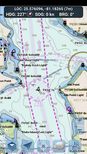
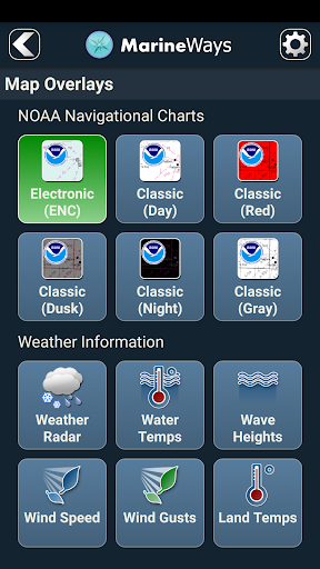
NAVIGATIONAL CHARTS
- United States charts provided by National Oceanic and Atmospheric Administration (NOAA)
- New Zealand charts provided by Land Information New Zealand (LINZ)
Chart types:
- NOAA Electronic Navigational Charts (ENC) (NOAA's newest and most powerful electronic charting product).
- NOAA classic charts (including Day, Red, Dusk, Night, and Gray versions).
- LINZ charts (available in Day, Dusk, and Night versions only currently)
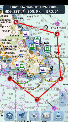
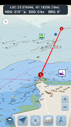
ROUTE PLANNING TOOLS
-Route Plotting. Tap and hold on the map for one second to plot your waypoints. To form a route, continue to tap and hold on the map in different areas. Distance and bearing are conveniently calculated and displayed for each leg as you add, adjust, or remove waypoints.
-Travel Mode. Automatically centers the map on your current position as you move. Use travel mode to see how closely you are following your plotted route in real time!
-Route Leg Summary. A convenient view containing detailed information of each leg you have plotted, including start and end coordinates, distance, and bearing.
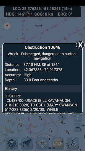
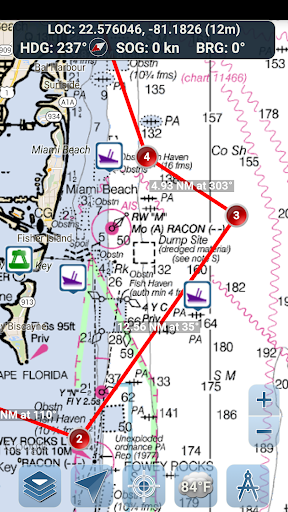
BUOY REPORTS AND OBSTRUCTION INFORMATION
Markers for buoys and obstructions are conveniently plotted in their actual location on the map! Just click on the marker to view their information!
- Buoy Reports: Get complete current conditions and wave reports for fixed and drifting buoys.
- Obstructions: Get location and history information about potentially dangerous, submerged hazards including rocks and sunken vessels.
NAVIGATION DASHBOARD
The navigational dashboard shows various real-time information including:
- Current location (latitude and longitude, with accuracy range)
- Current Heading (includes a small directional compass as well!)
- Current Speed Over Ground
- Current Bearing
MARINE MAP OVERLAYS
Toggle various marine overlay data right onto the map to get a better idea of the current boating conditions!
Overlays include:
- Water Surface Temperature (Global)
- Wind Speeds (US only)
- Wind Gusts (US only)
- Wave Heights (US only)
LOCATION SHARING OVER WATER / VIEW OTHER BOATS
- Display your last known location, speed, bearing, and boat name on the map for other Marine Ways boaters to view.
- View the last known location, speed, bearing, and boat name of other Marine Ways boaters, as well as their distance and bearing from your location.
- Location sharing is turned off by default. When you are ready to share, toggle it on within general settings. To continuously update your location on the map, keep the app opened and focused. The app currently does not update your location in the background.
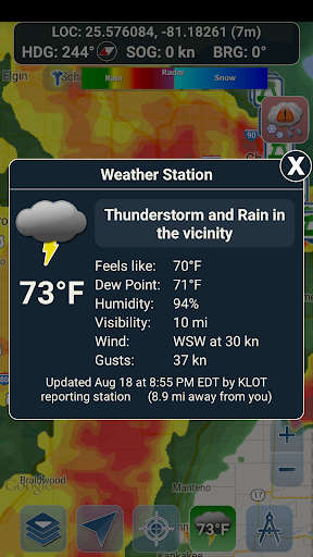
WEATHER INFORMATION
- Weather Precipitation Radar (US & Hawaii only). Detects any rain and snow in the area.
- Weather Station. Reports the nearest observation station data. Current temperature, humidity, weather conditions, wind, and more! Station observation data is available globally.
- Weather Alerts. Weather station also reports any active weather alerts issued by the National Weather Service such as severe thunderstorm warnings or hurricane warnings. Weather alert information is available for US, Alaska and Hawaii.
- Land Surface Temperature overlay. Shows the current surface temperature on land (US only).
Before using this application, please read and agree to the following terms of use / service and privacy policy:
Terms of Use / Service: http://www.marineways.com/appterms
Privacy policy: http://www.marineways.com/appprivacy
Navigational Charts Disclaimer from NOAA:
NOAA ENC Online is not certified for navigation. Screen captures of the ENCs displayed here do NOT fulfill chart carriage requirements for regulated commercial vessels under Titles 33 and 46 of the Code of Federal Regulations.
Enjoy the app! Marine Ways is also available on the web at http://www.marineways.com
NAVIGATIONAL CHARTS
- United States charts provided by National Oceanic and Atmospheric Administration (NOAA)
- New Zealand charts provided by Land Information New Zealand (LINZ)
Chart types:
- NOAA Electronic Navigational Charts (ENC) (NOAA's newest and most powerful electronic charting product).
- NOAA classic charts (including Day, Red, Dusk, Night, and Gray versions).
- LINZ charts (available in Day, Dusk, and Night versions only currently)
ROUTE PLANNING TOOLS
-Route Plotting. Tap and hold on the map for one second to plot your waypoints. To form a route, continue to tap and hold on the map in different areas. Distance and bearing are conveniently calculated and displayed for each leg as you add, adjust, or remove waypoints.
-Travel Mode. Automatically centers the map on your current position as you move. Use travel mode to see how closely you are following your plotted route in real time!
-Route Leg Summary. A convenient view containing detailed information of each leg you have plotted, including start and end coordinates, distance, and bearing.
BUOY REPORTS AND OBSTRUCTION INFORMATION
Markers for buoys and obstructions are conveniently plotted in their actual location on the map! Just click on the marker to view their information!
- Buoy Reports: Get complete current conditions and wave reports for fixed and drifting buoys.
- Obstructions: Get location and history information about potentially dangerous, submerged hazards including rocks and sunken vessels.
NAVIGATION DASHBOARD
The navigational dashboard shows various real-time information including:
- Current location (latitude and longitude, with accuracy range)
- Current Heading (includes a small directional compass as well!)
- Current Speed Over Ground
- Current Bearing
MARINE MAP OVERLAYS
Toggle various marine overlay data right onto the map to get a better idea of the current boating conditions!
Overlays include:
- Water Surface Temperature (Global)
- Wind Speeds (US only)
- Wind Gusts (US only)
- Wave Heights (US only)
LOCATION SHARING OVER WATER / VIEW OTHER BOATS
- Display your last known location, speed, bearing, and boat name on the map for other Marine Ways boaters to view.
- View the last known location, speed, bearing, and boat name of other Marine Ways boaters, as well as their distance and bearing from your location.
- Location sharing is turned off by default. When you are ready to share, toggle it on within general settings. To continuously update your location on the map, keep the app opened and focused. The app currently does not update your location in the background.
WEATHER INFORMATION
- Weather Precipitation Radar (US & Hawaii only). Detects any rain and snow in the area.
- Weather Station. Reports the nearest observation station data. Current temperature, humidity, weather conditions, wind, and more! Station observation data is available globally.
- Weather Alerts. Weather station also reports any active weather alerts issued by the National Weather Service such as severe thunderstorm warnings or hurricane warnings. Weather alert information is available for US, Alaska and Hawaii.
- Land Surface Temperature overlay. Shows the current surface temperature on land (US only).
Before using this application, please read and agree to the following terms of use / service and privacy policy:
Terms of Use / Service: http://www.marineways.com/appterms
Privacy policy: http://www.marineways.com/appprivacy
Navigational Charts Disclaimer from NOAA:
NOAA ENC Online is not certified for navigation. Screen captures of the ENCs displayed here do NOT fulfill chart carriage requirements for regulated commercial vessels under Titles 33 and 46 of the Code of Federal Regulations.
Enjoy the app! Marine Ways is also available on the web at http://www.marineways.com
Marine Ways - Nautical Charts Screenshots
Old Versions of Marine Ways - Nautical Charts


Apps Like Marine Ways - Nautical Charts
 Marine Ways - Nautical Charts4.8
 Nautical Charts — OsmAnd4.8
 Nautical Life : Boats & Yachts4.9
 Nautical Life 24.7
 Nautical Flags4.1
 Nautical Calculator4.8
 Nautical Flags Helper4.4
 The Nautical School ExamTutor+4.7
 Nautical Almanac4.9
 Nautical Calculators4.7
 WWF Nautical Chart4.7
 Alto Minho Nautical and Nature4.9
Marine Ways - Nautical Charts FAQ
How do I download Marine Ways - Nautical Charts from PGYER APK HUB?
Is the Marine Ways - Nautical Charts on PGYER APK HUB free to download?
Do I need an account to download Marine Ways - Nautical Charts from PGYER APK HUB?
How can I report a problem with Marine Ways - Nautical Charts on PGYER APK HUB?
Did you find this helpfull
Yes
No
User Reviews
+ Reviews
4.8
5
4
3
2
1
M
Margaret
2024-12-31
4
0
Marine Ways - Nautical Charts is an essential tool for any sailor or boating enthusiast. The detailed charts and user-friendly interface make navigation a breeze.
L
Lori
2025-01-25
7
0
Marine Ways - Nautical Charts has revolutionized my boating experience. The app is intuitive, and the offline mode is a lifesaver in remote areas.
S
Shawn
2024-12-26
17
0
As a professional mariner, I highly recommend Marine Ways - Nautical Charts. The app provides up-to-date information and is a must-have for safe navigation.
Most Popular
Hyper
Hyper
4.9Microsoft Word: Edit Documents
Microsoft Corporation
4.6PRX XIT MOBILE PANEL
PRX XIT MOBILE PANEL - Comprehensive Overview
Introduction
Discover the PRX XIT MOBILE PANEL, a cutt
4.9Mega888
Mega888 APK - Ultimate Gaming Experience at Your Fingertips
Overview:
Discover the thrilling world o
4.6KOPLO77
KOPLO77 APK - Comprehensive Overview
Discover the vibrant world of KOPLO77, an innovative applicatio
4.6LostLife
Lost Life APK Download and Guide
Today, we're exploring Lost Life, a popular 3D simulation horror ga
4.9PLN Mobile
P L N
4.7Aviator Predictor
Сергей Братухин
-MiChat - Chat, Make Friends
MICHAT PTE. LIMITED
4.0WEBTOON
NAVER WEBTOON
4.6SuperFishing Casino- Slots 777
Joyous.games
4.6ChatGPT
OpenAI
4.8Svipbet.club
TippoParty
4.6WePlay(ويبلاي) - Game & Chat
WEJOY Pte. Ltd.
4.6HeeSay - Blued LIVE & Dating
iRainbow
4.1Max: Stream HBO, TV, & Movies
WarnerMedia Global Digital Services, LLC
4.7App Market
Oppo
4.6ENUYGUN
WINGIE ENUYGUN GROUP
4.7Naruto Senki
Naruto Senki APK is a mobile fighting game inspired by the popular Naruto anime and manga series. It
4.6Game Booster VIP Lag Fix & GFX
TOLAN
4.8999+ Gamebox
AyYıldız
4.8BIGO LIVE Lite – Live Stream
Bigo Technology Pte. Ltd.
4.3InstaGold
Assem Mahgoob
4.8GTA 6
RICHIEMANMARIO ALT
3.2