Nautical Charts — OsmAnd
4.8Rating
Jul 11, 2024Latest update
1.0Version
About Nautical Charts — OsmAnd
Nautical Charts — OsmAnd is an extension for OsmAnd Maps & Navigation app that provides free nautical charts for offline use. This sea map will be your reliable companion whether you are going fishing or planning a sea travel.
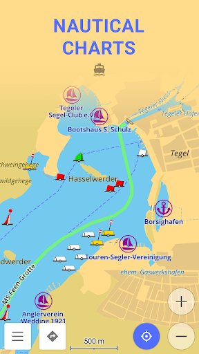
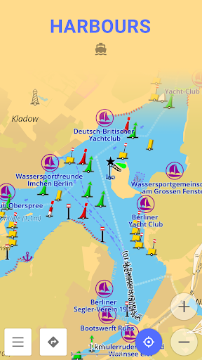
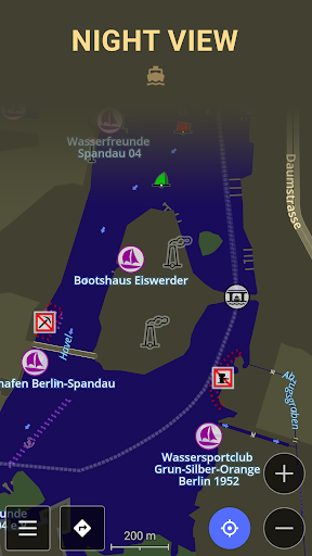
Nautical Charts are a detailed graphical representation of oceans, seas, coastal areas, and rivers. The charts can contain various information like sailing routes, navigation lights, dangerous areas, areas where it's allowed or not allowed to sail or dock, etc.
These maps are also supplemented with the information about the depth contours and nautical depth points that add valuable layers of data to the map.
All the professional sailors are obliged to have official marine charts
on their ships. These charts are published by authorized agencies and cost quite some money. Agencies are investing a lot in keeping the charts up to date. They release updates for the charts on a regular basis, but because of the fact that reviewing the information and processing the updates takes quite some time, the nautical charts are never completely up-to-date.
Nautical charts by OsmAnd are based on the data from the OpenSeaMap project. The idea of the project is to build the detailed map by people who actually use it. Every user of the map can contribute by adding changes to it making it more detailed and more accurate.
While OpenSeaMap charts at the moment cannot compete with official nautical charts, they can be used by recreational sailors for orientation or route planning. This plugin does not provide nautical navigation but it is your offline reference tool that can be used together with other navigational programs.
Usage Instructions: it is highly recommended to download nautical basemap in order to see the maps regardless of detailed map presence. Nautical charts are provided as a map and a special style, to switch style in OsmAnd please use the menu item 'Configure Map' on the map screen.
Nautical Charts — OsmAnd Screenshots

Old Versions of Nautical Charts — OsmAnd


Apps Like Nautical Charts — OsmAnd
 Nautical Charts — OsmAnd4.8
 Marine Ways - Nautical Charts4.8
 OsmAnd — Maps & GPS Offline4.5
 OsmAnd Nightly4.7
 OsmAnd - Offline Maps and GPS Navigation4.7
 OsmAnd-map-sample4.8
 OsmAnd API Demo4.7
 Parking Plugin — OsmAnd4.3
 Ski Map Plugin — OsmAnd4.6
 OsmAnd SRTM4.8
 Contour lines plugin — OsmAnd4.8
 OsmAnd Online GPS Tracker4.6
Nautical Charts — OsmAnd FAQ
How do I download Nautical Charts — OsmAnd from PGYER APK HUB?
Is the Nautical Charts — OsmAnd on PGYER APK HUB free to download?
Do I need an account to download Nautical Charts — OsmAnd from PGYER APK HUB?
How can I report a problem with Nautical Charts — OsmAnd on PGYER APK HUB?
Did you find this helpfull
Yes
No
User Reviews
+ Reviews
4.8
5
4
3
2
1
A
Abel
2025-01-08
21
0
Nautical Charts — OsmAnd is an exceptional app for marine navigation. The detailed charts and real-time updates make it my go-to tool for sailing.
P
Peggy
2024-12-24
26
0
I absolutely love using Nautical Charts — OsmAnd. The interface is user-friendly and the accuracy of the charts is top-notch.
O
Octavia
2024-12-28
4
0
Nautical Charts — OsmAnd has revolutionized my boating experience. The app is packed with features that make navigation a breeze.
Most Popular
Hyper
Hyper
4.9Microsoft Word: Edit Documents
Microsoft Corporation
4.6PRX XIT MOBILE PANEL
PRX XIT MOBILE PANEL - Comprehensive Overview
Introduction
Discover the PRX XIT MOBILE PANEL, a cutt
4.9Mega888
Mega888 APK - Ultimate Gaming Experience at Your Fingertips
Overview:
Discover the thrilling world o
4.6KOPLO77
KOPLO77 APK - Comprehensive Overview
Discover the vibrant world of KOPLO77, an innovative applicatio
4.6LostLife
Lost Life APK Download and Guide
Today, we're exploring Lost Life, a popular 3D simulation horror ga
4.9PLN Mobile
P L N
4.7Aviator Predictor
Сергей Братухин
-MiChat - Chat, Make Friends
MICHAT PTE. LIMITED
4.0WEBTOON
NAVER WEBTOON
4.6SuperFishing Casino- Slots 777
Joyous.games
4.6ChatGPT
OpenAI
4.8Svipbet.club
TippoParty
4.6WePlay(ويبلاي) - Game & Chat
WEJOY Pte. Ltd.
4.6HeeSay - Blued LIVE & Dating
iRainbow
4.1Max: Stream HBO, TV, & Movies
WarnerMedia Global Digital Services, LLC
4.7App Market
Oppo
4.6ENUYGUN
WINGIE ENUYGUN GROUP
4.7Naruto Senki
Naruto Senki APK is a mobile fighting game inspired by the popular Naruto anime and manga series. It
4.6Game Booster VIP Lag Fix & GFX
TOLAN
4.8999+ Gamebox
AyYıldız
4.8BIGO LIVE Lite – Live Stream
Bigo Technology Pte. Ltd.
4.3InstaGold
Assem Mahgoob
4.8GTA 6
RICHIEMANMARIO ALT
3.2